
Serĉrezultoj
Ĉu vi intencis: „s mars“?
- Krei la paĝon "S maps" en ĉi tiu vikio!
- Serĉu la artikolon S maps en WikiTrans (maŝintraduko de la anglalingva Vikipedio).
- 2002-12-10 per la retarkivo Wayback Machine http://bulgaria.domino.bg/maps/eng/maps.htm?sofia Arkivigite je 2008-01-17 per la retarkivo Wayback Machine...2 KB (148 vortoj) - 14:09, 8 sep. 2023
 Aŭstralia Antarkta Teritorio (kategorio 75° S)http://aadc-maps.aad.gov.au/database/mapcat/antarctica/v4_99_00.pdf Arkivigite je 2008-09-07 per la retarkivo Wayback Machine http://aadc-maps.aad.gov...3 KB (194 vortoj) - 12:12, 21 feb. 2024
 Koncepciono (kategorio 36° S)Koncepciono en la Vikimedia Komunejo (Multrimedaj datumoj) Municipa retejo de Koncepciono Concepción (Google Maps) Encyclopædia Britannica — Koncepciono...2 KB (133 vortoj) - 19:22, 7 apr. 2024
 Lusako (kategorio 15° S)milionurboj http://www.zambiatourism.com/travel/cities/lusaka.htm http://www.zambiatourism.com/travel/maps/lusakacity.htm Turismaj informoj[rompita ligilo]...5 KB (187 vortoj) - 20:22, 12 apr. 2024
 Luján (rivero) (kategorio 34° S)54111 °U / -34.43194; -58.54111 (mapo) ↑ GEOnet2 32FA883863283774E0440003BA962ED3 Río Luján ↑ GNS coordinates adjusted using Google Maps and GeoLocator...1 KB (89 vortoj) - 10:36, 15 jan. 2024
 Laguna del Carbón (Santa Cruz) (kategorio 49° S)de Argentino Interpatagonia. Laguna del Carbón ĉe Google Maps 49° 35′ 19″ S 68° 20′ 30″ U / 49.58861 °S, 68.34167 °U / -49.58861; -68.34167 (mapo)...1 KB (98 vortoj) - 20:16, 8 maj. 2024
 Tasmana Maro (kategorio 37° S)Koralmaraj Insuloj) 40° S 160° O / 40 °S, 160 °O / -40; 160 (mapo) ↑ Rāwiri Taonui. Tapa whenua – naming places - Events, maps and European influences...2 KB (239 vortoj) - 16:11, 25 nov. 2023
- je 2011-12-25. Alirita 2010-02-01. François, Alexandre (2008), "Semantic maps and the typology of colexification: Intertwining polysemous networks across...3 KB (308 vortoj) - 11:31, 14 nov. 2023
 terkolo de Tehuantepeko. Atlas of Mexico, 1975 (http://www.lib.utexas.edu/maps/atlas_mexico/river_basins.jpg). The Prentice Hall American World Atlas, 1984...1 KB (130 vortoj) - 12:45, 22 apr. 2024
- groups of immersions and embeddings (1991) On realizing homology classes by maps of restricted complexity (2013) hungarlingva biografio universitata paĝo...1 KB (101 vortoj) - 15:38, 15 jul. 2022
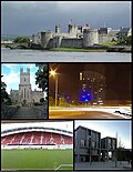 (Multrimedaj datumoj) http://www.limerick.com http://maps.msn.com/map.aspx?ID=27CiJ.&C=52.66101,-8.6327&L=EUR&A=50&S=405,320&P=%7c490f%7c&PN=1065196372&TI=Lime...6 KB (237 vortoj) - 09:42, 21 nov. 2023
 Forestry Service ↑ angle A Tapestry of Time and Terrain: The Union of Two Maps - Geology and Topography. United States Geological Survey. Alirita 2007-10-13...3 KB (176 vortoj) - 06:59, 6 feb. 2024
 karakteroj de granda nombro de la monda lingvoj. Ĝi interrilatas kun Google Maps. La informoj de la atlaso eldonitas sub la permesilo Krea Komunaĵo. Ili ankaŭ...2 KB (193 vortoj) - 12:29, 24 nov. 2023
 Puerto Madryn (kategorio 42° S)Costa, Andes Celtig / Google Maps ↑ «Argentina: Provinces, Departments, Cities, Localities & Agglomerations - Statistics & Maps on City Population». [2] Konsultita...2 KB (206 vortoj) - 16:26, 29 okt. 2023
 Malfeliĉaj Insuloj (kategorio 26° S)Vikimedia Komunejo (Multrimedaj datumoj) angle Ekoregiono NT0403 : San Felix kaj San Ambrosio Insuloj (WWF) angle GoogleMaps mapo de San Felix island...3 KB (298 vortoj) - 07:33, 16 sep. 2023
- 1100 cm-ojn vasta, ŝajne la plej granda en Hungario hungara Vikipedio http/maps.google.com www.iranymagyarorszag.hu www.gyaloglo.hu www.vendegvaro.hu Kategorio...1 KB (132 vortoj) - 11:44, 23 nov. 2023
 Koro de Jesuo kastelo de Széchenyi [sEĉEnji] Márton Kálmáncsehi Sánta naskiĝis en Kálmáncsa hungara Vikipedio http/maps.google.com www.iranymagyarorszag...1 KB (165 vortoj) - 14:31, 29 aŭg. 2023
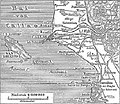 Insulo San Lorenzo (Peruo) (kategorio 12° S)2005-02-13. Alirita 2005-02-13. Kategorio Insulo San Lorenzo (Peruo) en la Vikimedia Komunejo (Multrimedaj datumoj) Insulo San Lorenzo en Google Maps...2 KB (260 vortoj) - 19:04, 29 jul. 2023
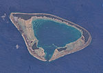 Haraiki (kategorio 17° S)havas pasejon en la sudo. Haraiki estas permanente neloĝata. Tamen, Google Maps malkovras ke estas kelkaj konstruaĵoj je la norda marbordo (-17.446343,-143...3 KB (222 vortoj) - 11:03, 17 nov. 2023
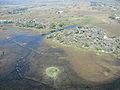 Okavanga Delto (kategorio 19° S)la retarkivo Wayback Machine Information Website on the Okavango Delta - maps, photos, blogs Arkivigite je 2011-04-26 per la retarkivo Wayback Machine...5 KB (431 vortoj) - 17:09, 2 dec. 2023


